

No expiration date
Easy refund
Free exchange
Easy booking
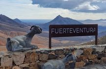
Fuerteventura: Discover ALL the wonders & hidden gems. MAX 8 pax
$91.11
This is an experience gift voucher. The recipient will book the experience after
they redeem the gift voucher.
Overview
Discover the hidden gems of Fuerteventura
In a luxury, air-conditioned minibus with an expert local guide, you will explore places inaccessible to large buses in a select group, max. 8 people.
In about 6 max 7 hours, you will travel from magic north to the sandy south.
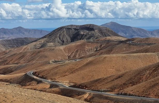
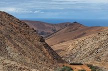
You will traverse the spectacular mountain landscape surrounding the ancient capitals of La Oliva and Betancuria, famous for their challenging hairpin bends and breathtaking panoramas.
Along the way, you can discover and walk to the mysterious limestone caves on the west coast, walk along pristine black sand beaches, and enjoy the tranquility of the charming fishing village Ajuy
From the snow-white dunes in the north to the impressive Sicasumbre viewpoints in the south, from where we can admire the Jandia protected nature park, this tour offers the perfect combination!
A day full of photo opportunities and pure relaxation.
Sometimes we sit on the bus a little longer, but don't worry, there is plenty to see.
In a luxury, air-conditioned minibus with an expert local guide, you will explore places inaccessible to large buses in a select group, max. 8 people.
In about 6 max 7 hours, you will travel from magic north to the sandy south.
You will traverse the spectacular mountain landscape surrounding the ancient capitals of La Oliva and Betancuria, famous for their challenging hairpin bends and breathtaking panoramas.
Along the way, you can discover and walk to the mysterious limestone caves on the west coast, walk along pristine black sand beaches, and enjoy the tranquility of the charming fishing village Ajuy
From the snow-white dunes in the north to the impressive Sicasumbre viewpoints in the south, from where we can admire the Jandia protected nature park, this tour offers the perfect combination!
A day full of photo opportunities and pure relaxation.
Sometimes we sit on the bus a little longer, but don't worry, there is plenty to see.
—
Fuerteventura: Discover ALL the wonders & hidden gems. MAX 8 pax
Pickup included
Pickup included
Tour guide
Language: English
Human tour guide
Duration: 6 hours
- Luxury air-conditioned minibus
- Slow Tourism! NO stress!
- Photostops in mountains/volcanoes
- Air-conditioned vehicle
- Free time to explore & shopping
- Multilingual local guide
- Visit to natural limestone caves
- NO pick ups in Jandia (South)
-
Dunas De CorrallejoNeither the Seychelles nor the Caribbean: the best beach in the world according to National Geographic is in the Canary Islands. One of the best beaches in the world is Corralejo, and we'll definitely be seeing it on this tour! Our guide, Pierre, rightly calls it: “ The door to Paradise” • If we have enough time, we will also stop by the dunes.
-
BetancuriaBeautiful old historical village from 1404! The oldest and the first capital of FuerteVentura… your guide will tell you all about it…
-
AjuyAuthentic Canarian Cuisine: Lunch on Volcanic Beaches A lunch at a traditional Canarian restaurant on a jet-black volcanic beach offers a unique combination of gastronomy and nature. The Canary Islands archipelago is known for its impressive volcanic landscapes and a rich, pure culinary culture. Local gastronomy excels in simplicity and the high quality of daily fresh products, with a leading role for fresh fish, local goat meat, and artisanal cheeses.
-
Playa de AjuyTHE Walk to the caves ! The oldest rock formations in the Canary Islands The oldest rock formations in the Canary Islands come to the surface in the Ajuy Caves, which have been declared a Natural Monument and are located in the town of the same name, north of the village of Pájara. This geological wonder consists of observing with the naked eye the deposits that formed in the ocean floor during the Cretaceous period, between 100 and 150 million years ago. It is a mystery, because the formation of Fuerteventura dates back to approximately 30 million years ago. Access to the caves is a remarkable experience, because you walk along a fossilized sand dune, and along the way you can see some old lime kilns, which are unique because the stones were shipped directly into the sea. In the area around Ajuy you will also find places of interest such as the Canarian palm grove of Madre del Agua, along the same ravine that the conquistadors crossed 600 years ago,.
-
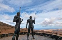
Mirador Guise y AyoseGuise and Ayose Viewpoint This viewpoint is named after the two ancient Kings of Fuerteventura who ruled the two kingdoms that made up the island: Jandía and Maxorata. The viewpoint, which houses statues of the two rulers, is located right where the two kingdoms once separated. From there, you can enjoy the Betancuria Valley and the volcanic northern half of Fuerteventura, as well as the surrounding villages. The design of the statues is from our local architect señor Miquel Cubas
-
Mirador de las PenitasPanoramic View: From this viewpoint, a breathtaking view unfolds. The underground river that flows beneath the Las Peñitas ravine emerges thanks to human intervention, forming a small lake surrounded by native plants. It is a place where nature and human intervention intertwine in an astonishing way.
-
Ermita de la PenaOur church, The Ermita de la Virgen de la Peña in Betancuria area ( Vega de Rio Palmas) refers to two distinct but deeply connected religious sites in Fuerteventura honoring the Virgen de la Peña (the Virgin of the Rock), who is the patron saint of the island. Info: The church is an 18th-century building built by agreement among the island's residents, who decided to build a new temple in honor of their patron saint, the Virgin of Our Lady of the Rock.
-
Mirador SicasumbreDriving south, we arrive at the Sicasumbre Viewpoint, located about 300 meters above sea level. This is, by the way, one of the best places on our island to observe the sky and the Natural Park Jandia in the South! The beauty of the area is perfectly combined with the facilities the viewpoint offers, from information and signage to the mountains, so those who wish can comfortably use their cameras. Our guide, Pepe, says: "It's a panoramic and breathtaking viewpoint on clear, cloudy days. "We'll stop there whenever the weather conditions are favorable, without fail."
-
Tindaya"La Casa Alta" (The High House) in Tindaya was closely associated with the witches of Tindaya. La Casa Alta in Tindaya is an example of the civil architecture that flourished in the 18th century. Its walls enshrine memories and legends. Legend has it that Mount Tindaya has been a witches' haven since ancient times, ever since the Majos performed their rituals on its summit. There, magic, intertwined with the divine, spawned countless stories that resonated through the village. Good and evil, mystery and precision, the rain that brought life and death—always death—came from the mountain. From the mountain, the witches descended and took advantage of the darkness of the night to discuss earthly matters, for they were the ones who determined the entire course of events in the village of Tindaya. And according to legend, all those who still wandered through the village at sunrise sought refuge in the High House.
- We will pass by the natural lava park Malpais Grande . if time enough we have a short stop on the farm… (pass by)
- We are driving through the center of Puerto del Rosario to give you a good idea of our capital since 1862. More info from your multilingual local guide. (pass by)
How it works?
01
—
You choose from 10,000+ experience gifts
02
—
We deliver the eVoucher or the Physical box to the recipient
03
—
Recipient books the experience and creates unforgettable memories!
Fuerteventura: Discover ALL the wonders & hidden gems. MAX 8 pax
$91.11
This is an experience gift voucher. The recipient will book the experience after
they redeem the gift voucher.
How it works?
01
—
You choose from 10,000+ experience gifts
02
—
We deliver the eVoucher or the Physical box to the recipient
03
—
Recipient books the experience and creates unforgettable memories!